How satellite and communication technologies improve disaster response
Managing and responding to disasters is an increasing concern for countries worldwide. The loss of property, life, and natural resources are harsh realities that have to be addressed. For many governments and development agencies, finding new and better methods of disaster response is a priority.
According to a report by the Center for Research on the Epidemiology of Disasters (CRED), in 2016 564.9 million people were directly affected by natural disasters. During the same year, the estimated economic loss brought about by disasters was assessed at 153.9 billion USD.
According to Alberto Monguzzi, Disaster Management Coordinator for the International Federation of Red Cross and Red Crescent Societies “We estimate that for each dollar spent on disaster preparedness, an average of four dollars is saved on disaster response and recovery”. Preparing for disasters and implementing risk reduction measures can empower communities with the knowledge and tools to protect livelihoods and reduce number of lives lost.
Over time, technology has advanced, giving us better tools to respond and even prepare for disasters. Sadly, despite the rapid pace of technological development, countless lives are lost every year. According to CRED, from 2006 to 2015, the annual number of people who died directly as a result of natural disasters numbered over 69,000. This does not include the eventual deaths brought about by hunger, overexposure, and sickness that typically follow major natural disasters. One important tool to prevent and prepare for disasters is the usage of satellites and communication technology. And I believe its use can help solve a lot of problems.
Communications and on the ground response

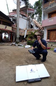
A technician using a satellite phone to communicate. Photo: Jeffrey Russell
Responding to disasters as they unfold poses a variety of concerns. Accurate, first-hand information on what is actually happening can be difficult to obtain. And having disaster response teams on the ground to assess situations and to provide information to decision-makers can be difficult. This is because disasters have a tendency to damage infrastructures, making access to affected areas difficult.
When natural disasters happen, local populations can be disoriented. Knowing the right course of action is critical. Rehearsed evacuation plans can fall to pieces when flooding or landslides make roads impassable.
Communication with people affected by disasters is critical in directing how governments and response teams act.
Where are the areas that are most affected? Which roads are blocked? Where relief command center can be situated? These are only some questions that disaster response teams and decision-makers need to answer to respond effectively.
SMS-based solutions
Today, mobile phones have become a staple means of communication. In recent years, prices for basic cellular phones have plummeted, allowing even the poor access to these. The widespread availability of these devices has made them an ideal tool for communication during emergencies.
The International Federation of Red Cross and Red Crescent Societies has developed a communication app called TERA, an SMS communication system that allows aid and responding agencies to communicate with people on the ground in real time.
The information delivered by the system is able to save lives and property. The technology allows the IFRC to bypass telecommunication procedures that broadcast messages to all network subscribers. Through the app, responders are able to specifically broadcast messages to a targeted city, or neighborhood. This funnels all messages toward the affected people who can then directly respond with the necessary preparation or evacuation.
There are a number of ways such systems benefit people. After earthquakes, populations are informed if a potential tsunami is arriving, and they must evacuate to higher ground. The source, direction, and speed of a wildfire can be disseminated, allowing communities to know how quickly and in which direction to evacuate. Days prior to a major hurricane, people in rural localities can be informed ahead of time with instructions on whether to simply prepare for the storm or evacuate. These are only a few examples.
Overcoming damaged communication infrastructure
Natural disasters, such as storms that bring strong winds and flooding, usually damage telecommunication infrastructure.
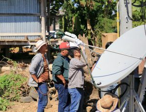
This is when satellite technology comes into play. Satellite phones and satellite-based broadband can still operate provided that there is power. This can allow people in affected areas to communicate what is currently happening, as well as give them the ability to receive safety and evacuation instructions from disaster rescue teams.
In the Philippines, a country prone to typhoons, app developers have started taking on the problem. Mobile apps such as FireChat, once installed into a mobile device, can turn them into individual communication nodes. The app allows the broadcast of the necessary information during disasters, even in the absence of functioning telecom infrastructures, and allow disaster response teams to act quickly.
Eyes in the sky

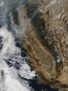
Satellite image of the California wildfire in 2017. Photo: NASA
Aside from being used as communication transmitters and receivers, meteorologists use satellites to capture imagery and remote sensing.
The 2017 wildfires in California razed over 990 sq kilometers of forest. It destroyed over 8,400 structures during the course of the fire. The vast destruction caused by the fire would have been worse if first response teams moved reactively. Thanks to the imagery acquired from weather satellites, response teams were able to strategically position themselves before the fire reached critical areas.
Satellites were also used after the fire was extinguished. Images acquired from satellites allowed the government to quickly assess which areas were hardest hit, allowing them to prioritize the resources need for aid and reconstruction.
Data collection for disaster mitigation
The United Nations Office for Disaster Risk Prevention is encouraging governments to capture more data with regard to disaster prevention and mitigation. In the past, data acquisition was done on an ad hoc basis, collecting information as the disaster was ongoing. Given current realities, the need for improved tools to collect and analyze data to create short and long-term mitigation plans has been acknowledged. Effectively acquiring data is the first step towards more effective disaster prevention and response.
Satellites have proven to be valuable tools in gathering data to lessen risks attributed to disasters. Remote sensing via satellite gives scientists valuable information to create risk models and vulnerability analyses. This makes disaster prevention a more scientific and thorough process for governments and responding agencies.
Proper management and direction of the government will be crucial in saving lives. The destruction that natural disasters can cause calls for governments to act decisively and seek out new and effective tools and methods. The use of communication technology is just one of these tools.
Governments should continually seek out partnerships with the private sector to push innovation and improve resilience to disasters. Individuals should have an open mindset when it comes to disaster safety and preparedness.
Some natural disasters are preventable, others are not. What is certain is that these events at one point or another will occur. With that reality in mind, we must all make an effort to minimize risks and damage that natural disasters cause when they do occur.


